

 |
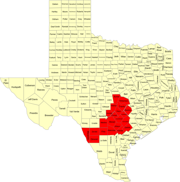
| …CRITICAL FIRE WEATHER CONDITIONS LIKELY ACROSS PORTIONS OF THE RIO GRANDE PLAINS, SOUTHERN EDWARDS PLATEAU, AND NORTHERN HILL COUNTRY REST OF TODAY DUE TO LOW RELATIVE HUMIDITY AND GUSTY WEST WINDS… …CRITICAL FIRE WEATHER CONDITIONS LIKELY ACROSS ALL AREAS EXCEPT LEE, FAYETTE AND LAVACA COUNTIES DUE TO LOW RELATIVE HUMIDITY AND GUSTY WEST WINDS… .Gusty west winds and dry air will continue to push into the region for the rest of this afternoon. In addition, hot temperatures along with the dry air will result in very low afternoon humidity levels in the single digits and low teens. The fire danger remains very high across the region. A strong cold front is forecast to push across the area on Wednesday with breezy northerly wind and gusts up to 35 mph. Minimum relative humidities are expected to drop to the teens and lower 20 percent values. Therefore, a Red Flag Warning has been issued for most areas on Wednesday as fire danger is very high across the region. Burnet-Williamson-Kendall-Blanco-Hays-Travis-Bastrop-Medina-Bexar- Comal-Guadalupe-Caldwell-Maverick-Zavala-Frio-Atascosa-Wilson- Karnes-Gonzales-De Witt-Dimmit- 328 PM CDT Tue Apr 5 2022 …RED FLAG WARNING IN EFFECT FROM 10 AM TO 8 PM CDT WEDNESDAY FOR WIND AND LOW RELATIVE HUMIDITY FOR ALL AREAS EXCEPT LEE, FAYETTE AND LAVACA COUNTIES… The National Weather Service in Austin/San Antonio has issued a Red Flag Warning for wind and low relative humidity, which is in effect from 10 AM to 8 PM CDT Wednesday. * WINDS…North 15 to 25 mph with gusts up to 35 mph. * RELATIVE HUMIDITY…As low as 10 percent. * IMPACTS…Any wildfires ignited may spread rapidly and unpredictably. PRECAUTIONARY/PREPAREDNESS ACTIONS… A Red Flag Warning means that critical fire weather conditions are either occurring now….or will shortly. A combination of strong winds…low relative humidity…and warm temperatures can contribute to extreme fire behavior. |