

| The National Weather Service Has Issued a Flood Watch for Bandera, Bastrop, Bexar, Blanco, Burnet, Caldwell, Comal, Edwards, Gillespie, Guadalupe, Hays, Kendall, Kerr, Kinney, Lee, Llano, Medina, Real, Travis, Uvalde, Val Verde, and Williamson Counties (A Watch is used when the risk of a hazardous weather or hydrologic event has increased significantly, but its occurrence, location or timing is still uncertain. A watch means that hazardous weather is possible. People should have a plan of action in case a storm threatens and they should listen for later information and possible warnings especially when planning travel or outdoor activities.) |
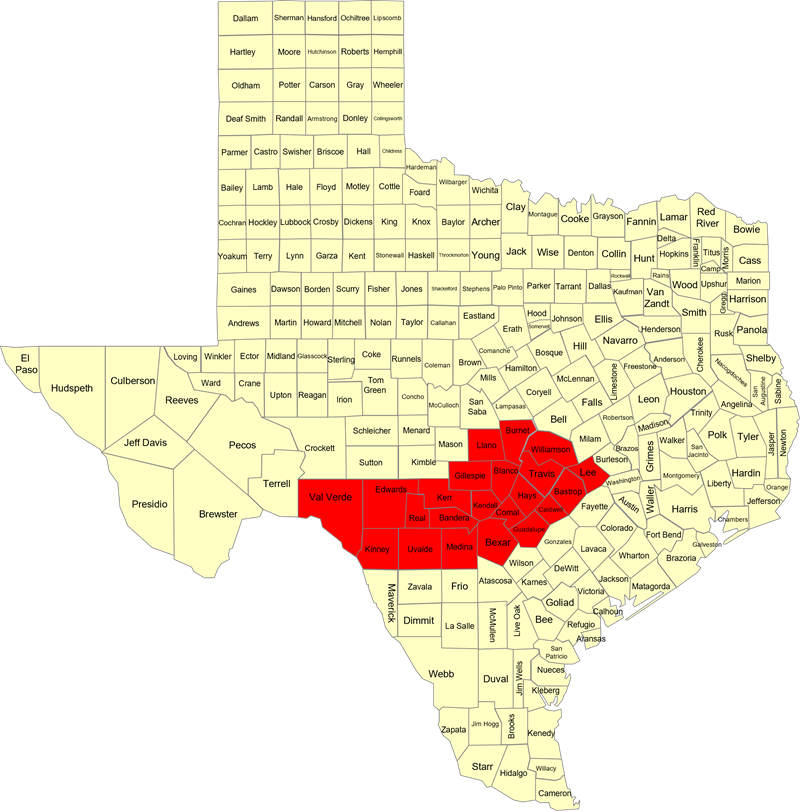
| 1051 AM CDT Fri Oct 24 2025 …FLOOD WATCH IN EFFECT FROM 7 PM CDT THIS EVENING THROUGH SATURDAY AFTERNOON… * WHAT…Flooding caused by excessive rainfall is possible. * WHERE…A portion of south central Texas, including the following counties, Bandera, Bastrop, Bexar, Blanco, Burnet, Caldwell, Comal, Edwards, Gillespie, Guadalupe, Hays, Kendall, Kerr, Kinney, Lee, Llano, Medina, Real, Travis, Uvalde, Val Verde and Williamson. * WHEN…From 7 PM CDT this evening through Saturday afternoon. * IMPACTS…1 to 3 inches of rainfall with isolated amounts up to 5 inches. Excessive runoff may result in life-threatening flooding of rivers, creeks, streams, and other low-lying and flood-prone locations in the Hill Country and southern Edwards Plateau as well as urban areas along the I-35 corridor. ADDITIONAL DETAILS…- http://www.weather.gov/safety/flood PRECAUTIONARY/PREPAREDNESS ACTIONS… You should monitor later forecasts and be alert for possible Flood Warnings. Those living in areas prone to flooding should be prepared to take action should flooding develop. |